“Somebody in Chaco Canyon Loves Me” is what the T-shirt says. Well, actually, it doesn’t. In fact, I don’t think the ranger station even sold T-shirts, but it should. I spent 8 hours this past weekend in an area of New Mexico that is regarded by many Native Americans as sacred, and is regarded by the Parks Department as a World Heritage site – Chaco Canyon. It is such a “worldly site” that our tour guide on one of the excursions was an exchange student from Italy.
Chaco Canyon is about 2 hours northwest of Albuquerque. An hour and half of which is on a paved highway – not a bad drive. Even the last 30 minutes of dirt road wasn’t bad either, until we came to the low water crossing. As our luck would have it, it rained the night before (being that this is the desert, rain is a rarity). The sign clearly said “Do not cross if water is flowing over the road”. Forget that! I didn’t fly 1.5 hours, and drive another two to turn back at that point. It took me about 15 seconds to convince my dad that our Mitsubishi Gallant could make it – and it did. The argument I presented went like this, “Dad. This is a rental car and the water aint that deep.” End of story - adventure #1 out of the way.
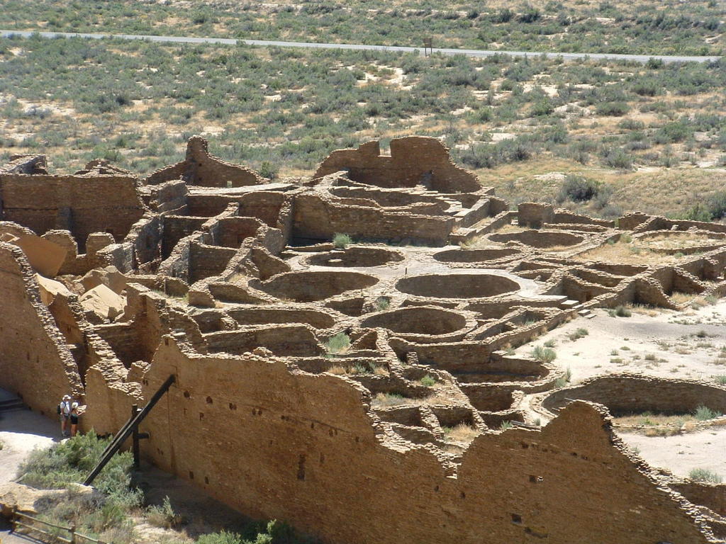
The Chacoan ruins are spread throughout the canyon on an 8 mile paved loop. It sure was nice of those ancient people to build close to the pavement. You can park you car and walk about 100-200 yards to the structures. The buildings range from being partially excavated to fully excavated to the point that you can walk through many of the rooms. One of the most impressive and the biggest, fully excavated was Pueblo Bonito. This thing was huge. It was at least 4 stories tall back around 900 – 1150 AD; currently the walls in some places are still 3 stories. Half of the pueblo is accessible – everything but the Kivas – which are round pits built into the ground for religious ceremonies and such.
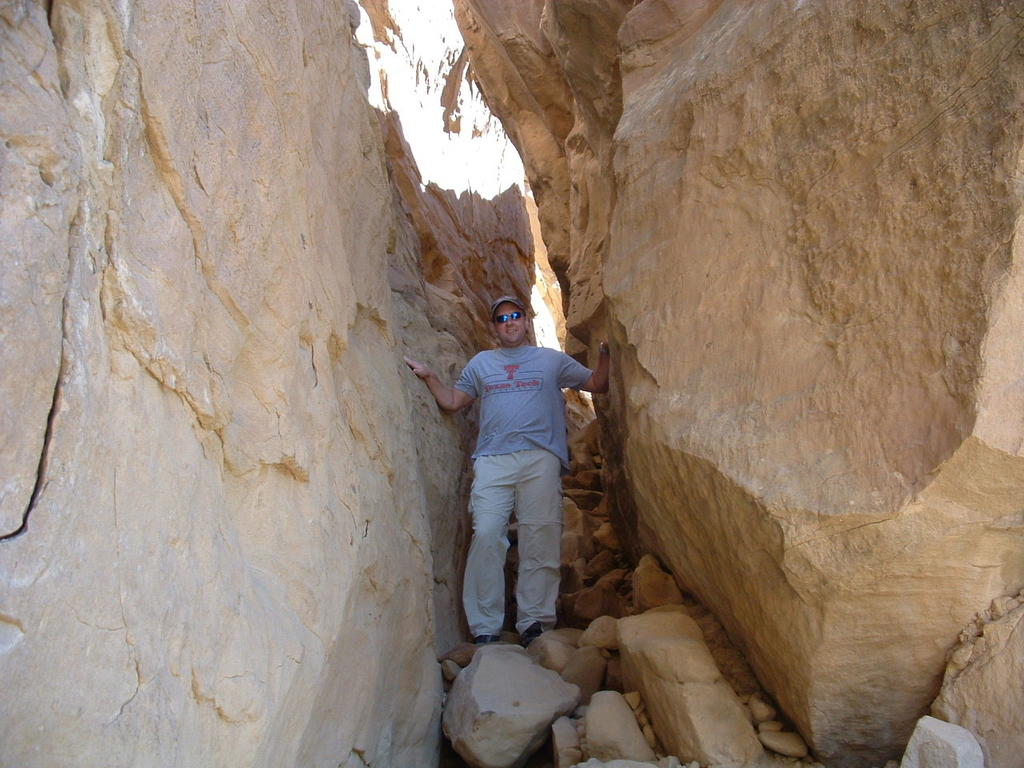
Up until this point, the trip was very cool, in an ancient sort of way. But we came for some hiking and hiking is what we did. Just up the road from Pueblo Bonito is the Pueblo Alto trailhead. This is the beginning of a 2.5-mile direct hike to Pueblo Alto or a 6-mile loop hike. The elevation change was only 500 feet from the canyon floor to the top of the mesa, but it was a fairly vertical ascent up large boulders and through an impressive rock chimney that would cause many people’s claustrophobia to act up. Once on top of the mesa it was about a half mile hike back above Pueblo Bonito for an excellent photo opportunity – taking in the entire Pueblo form on top. Another mile up the terraced steps to the ultimate top of the mesa and you arrived at Pueblo Alto - not nearly as well excavated but still worth the trip. The view looking out one of the doors of that Pueblo out into the canyon below was awesome.
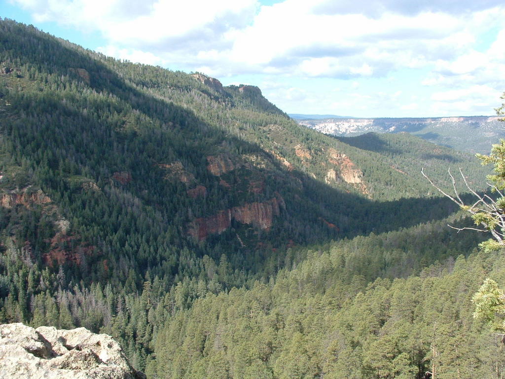
After leaving Chaco, we made the 2-hour drive to Santa Fe National Forest. Just north of Santa Fe and close to Los Alamos. What a difference 2 hours makes in the change of scenery. Scouted out the trailhead #137 that we were looking for and then went back to find some place to camp for the night. I won’t bore you with the camping details. It was pretty uneventful - other than to say we made a serious mistake by getting a cheap 2-man tent. Note to self, cut the occupancy in half based on what the box says.
Started the morning hike at 7 am after eating a breakfast of nothing. Breakfast was one of the things we overlooked when preparing for this excursion. We did have plenty of trail mix and some apples, which I quickly devoured about 45 minutes in. There are two trails you can take from the starting point. The first is a casual quarter-mile stroll to a really scenic waterfall – very easy. We did that in about 10 minutes, and then made it back to the “real” trail. This one is about a 3-mile trip to the McCauley Hot Springs. The first mile is mostly downhill and not too difficult. About 30 minutes in, there is a split in the trail off to the left – unmarked. Taking this split would prove to be one of the best experiences I have ever had. About 50 yards down you come to a jagged rocky overlook that peeks out of the forest. The view from the top of these rocks is unbelievable. The entire forest valley spreading out below and wilderness as far as the eye can see.
The next mile or so was up and down and varied from easy to strenuous. The final mile or so was mostly uphill. After about 2 hours we arrived at the springs. And after removing my shoes and getting in, I realized they should rename it the “Warm Springs” instead of “Hot Springs”. We rested here for about 30 minutes and started back. It was much harder going back given the uphill nature and being out of hiking shape.
That’s it. I would recommend this hike to anyone – from beginners to intermediate hikers. Those serious trailblazers may not find this super challenging, but it was about as much as I could take. Enjoy the pictures below and give me a ring next time anyone wants to take off to nowhere.
No comments:
Post a Comment